File Details |
|
| File Size | 13.2 MB |
|---|---|
| License | Shareware |
| Operating System | Windows 2000/9x/Server 2003/XP |
| Date Added | April 11, 2002 |
| Total Downloads | 608 |
| Publisher | Ambiente Informatica Ltda |
| Homepage | Polymap |
Publisher's Description
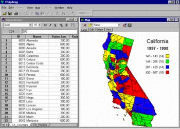
PolyMap is a desktop mapping program that lets you use your own data to customize the maps supplied with the program. Use the built-in spreadsheet to enter data or paste it from other Windows applications. Alternatively, you can use the import feature to bring in data from external spreadsheets, text, or database files. The Map Presentation Wizard gives you a step-by-step process to customize your map and the map's legend. Any data in a spreadsheet column may be utilized for labeling. You may use a set of geographic layers in different formats (state and county boundaries, five-digit ZIP codes, U.S. and state highways, cities, rivers, and lakes) to add details and create your new thematic map. Maps can be exported to Bitmap format (.bmp) enhanced Metafile (.emf) and JPEG (.jpg). This trial version will function for only 30 days and comes with only a fraction of the maps available in the registered edition.
